
An article written by Michael Blake Collins, P.S.

I am constantly astounded by the technology that surrounds us daily. We carry computers in our pockets, and there are cameras in our doorbells and thermostats that adjust the temperature in your house based on whether or not you are at home.
Surveying is one of the industries that has benefited from technological advancements. Virtual reference networks for our GPS equipment, drones collecting lidar data, and scanners that will mount to the back of your truck are all incredible advancements that many surveyors take advantage of every day. There is also GPS and LiDAR built into our phones.
So now that the technology that surveyors use is also used by the majority of the people around us, the question must be asked, “Has technology made the professional surveyor obsolete?”
While web-based GIS applications showing land parcels have been used for many years – by county tax assessors, in particular – the transition to mobile device-based apps with GPS integration is a bit newer. Now, with the correct device and app, anyone can look at a map that shows an aerial photograph and property lines together with a tiny blue dot indicating their position and instantly be standing “at their property corner.” With such astounding technology, why do we need to pay professional surveyors for services that anyone with a GPS-enabled cell phone and the correct app can perform on their own?

This issue hit home with me recently when I was surveying a piece of property for my dad. I had a copy of his deed, my GPS rover, data collector, metal detector, shovel, and flagging. He had his phone.
So, as I am searching for a monument at one of the corners, his phone is telling him that I am looking in the wrong area and should be 15-20 feet away from where I was digging. Even after finding the rebar with flagging at the corner, he still had a difficult time accepting that the monument I found was the actual corner because it was so far away from where his app showed the corner location to be. 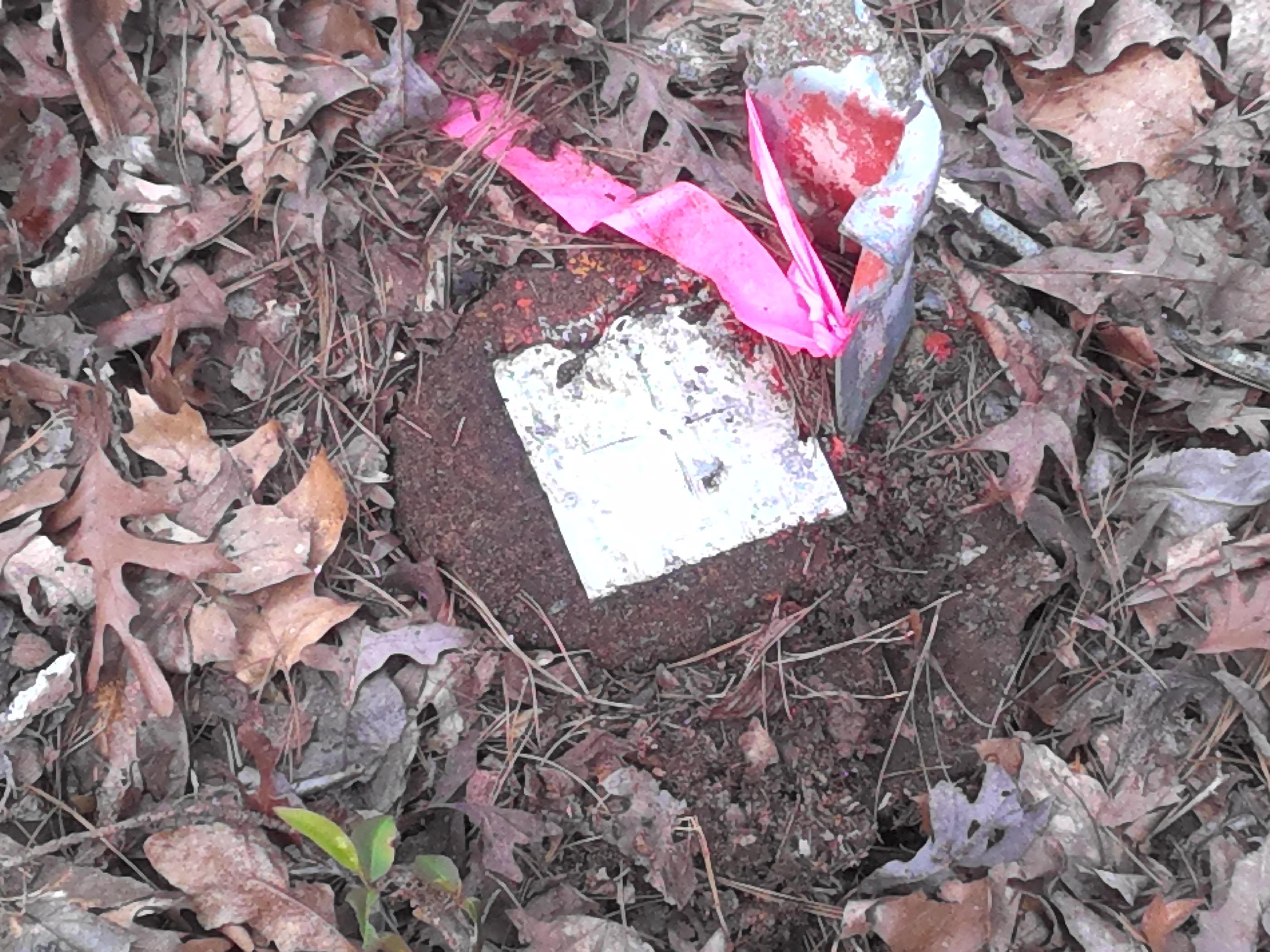
So why should he trust the location that I showed him instead of the location shown on his app?
I would argue that there are basically four reasons why!
Reason 1. Accuracy of the Equipment
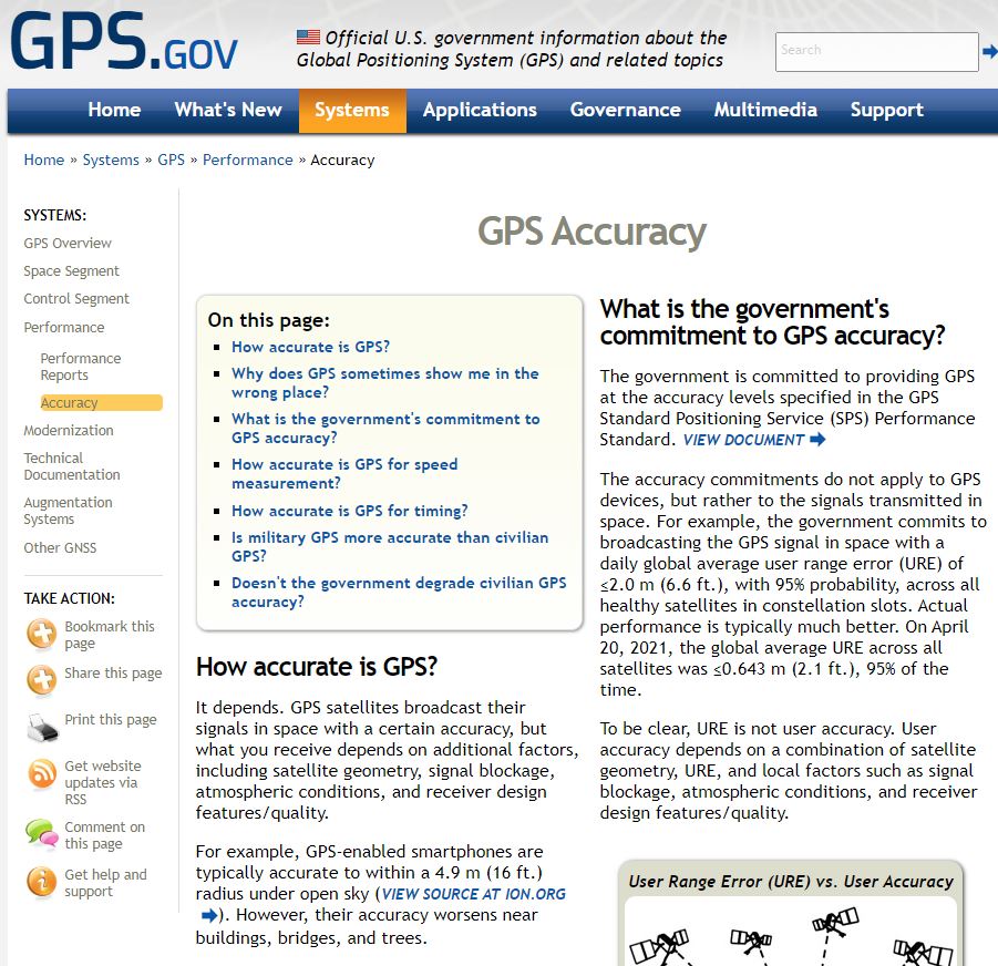
Most GPS-enabled smartphones have an accuracy of around 16 feet under ideal circumstances (https://www.gps.gov/systems/gps/performance/accuracy/). That accuracy can decrease dramatically if there are buildings or trees nearby. Again, the technology that allows you to pinpoint your location anywhere in the world to within 16 feet is imply mind blowing.
That level of accuracy is great if you are turned around in the woods and need to find your way back to your vehicle or if you are trying to find that trendy new restaurant. However, it is not nearly accurate enough for determining the location of a property line, which can affect your tax bill or how well you get along with your neighbor.
By contrast, most modern survey equipment can achieve GPS accuracies of +/- 1/2 inch.
Reason 2. Accuracy of the Data
The data represented in most of the apps that offer these services are obtained from county tax assessors. In essence, it is a tax map of the area. Tax maps are generally a decent indicator of the general size and shape of the parcel of land involved. Sometimes, they even have a good location when you compare it to aerial imagery obtained through Bing or Google Maps. However, on most of the tax assessor’s websites, you will find a disclaimer that says something to the effect of:
“The Assessor’s Office provides this information in good faith with no warranty and does not accept any liability arising from incorrect, incomplete, or misleading information or improper use. Be advised not to rely solely on the information reflected in these maps. … The maps and associated data at this website do not represent a survey” (Claiborne County Tax Assessor Web Application). “
Furthermore, the terms of service of one of the web-based apps has a section entitled “Accuracy of Information,” which contains the following regarding the accuracy of the data presented in their product:
“…the accuracy, completeness, timeliness, or correctness of (the) data is not guaranteed.”
It goes on to state, “The parcel data is neither a legally recorded map nor a survey and is not intended to be used as one. The parcel data … should be used for reference only. No representation is made that the features presented accurately reflect true location.” Furthermore, you do not know that the data presented is up to date. If a parcel has been divided or if a strip of land has been conveyed for a road right of way recently, then that information may not be shown on the county assessor’s page or the app.
On the other hand, surveyors physically locate each property corner, measure the angles and distances around the boundary, perform the related calculations, and conduct the necessary research to determine the exact boundaries of your property. Their data is individually gathered and checked for accuracy for each survey.
Reason 3. Awareness of the Law
While these apps and the tax maps that they are derived from are certainly useful tools for visualizing the boundary lines, there is often information in a deed that requires an interpretation by the reader, and awareness of boundary law and the language used in the deed is critical to interpreting that information properly. There may be conflicts in deeds of adjoining parcels that lead to gaps or overlaps.
A deed can even have conflicting information within itself. For example, the deed may say to go 100 feet to the right of way line of Main Street, but the right of way line of Main Street is more than 100 feet away. Would you only go 100 feet and come up short of the right of way line or ignore the distance and go to the right of way line? What if the deed follows a crooked ditch but the county has straightened the ditch to allow for better drainage? Does the property line follow the new line of the ditch or stay where the ditch was before the realignment?
These are all issues where a proper interpretation of boundary law is required to produce the correct location of the boundary line. County Tax Assessors and app developers know their employees often lack the expertise required to make those determinations. That is why they include those previously cited disclaimers on their websites and in their terms of service.
Surveyors, however, have the knowledge and experience to interpret these issues – and countless others like them –in accordance with state law to accurately locate property lines.
 Reason 4. Accountability
Who assumes liability should a landowner mark their boundary line using one of the apps that we have discussed? According to the terms of use quoted earlier, the same company states that they “assume no liability for any errors or omissions.” In other words, the landowner assumes total liability for any mistakes that this company makes, and they even take on the liability for inaccuracies in the data that they receive from the app they are using.
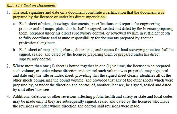
Conversely, the Rules and Regulations of the Mississippi Board of Licensure for Professional Engineers and Surveyors states in Chapter 14 that:
a surveyor is required to seal all surveys and that seal constitutes a certification that the document was prepared by the surveyor or under his/her direct supervision.
As such, the liability for errors is shifted to the surveyor who seals the document.
My dad is not a surveyor. He knows very little about what I do and how I do it. He is an avid wood worker, though. So, as we are standing over his property corner discussing the accuracy of the GPS in his phone and the accuracy of the data that he is trying to retrace, I asked him if he would ever use his miter saw to create a dovetail joint. He gave me a look of disgust, as though he could not believe I would ask such a ridiculous question, and replied with a resounding “NO!” “Why not?” I asked.
“Because it’s the wrong tool for the job.”
Technology is incredible. Phones with GPS and apps that show parcel information are particularly handy.
I know hunters who use them to look for access to their favorite spot. Others want to know who owns the parcel next to them so that they can butter them up and ask for permission to hunt (or at least know whose property they are going to be trespassing onto). Realtors and land developers use them for planning purposes as they work on their next major retail development or subdivision. Surveyors use them to know where to look to find section corners or other corners that will be required for our surveys. They are incredibly useful for the purpose for which they are intended.
However, they are simply the wrong tool for the job when it comes to accurately locating property lines.
Articles by contributors are not necessarily the viewpoint or opinion of the Mississippi Board of Licensure for Professional Engineers & Surveyors.